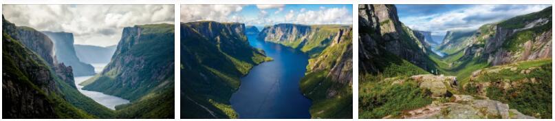
The 806 m high Gros Morne gave the park on the west coast of Newfoundland its name. The landscape is characterized by unique geological formations that are around 500 million years old. The mountain turns into a limestone plateau, which is covered by tundra vegetation and cut by fjords, watercourses, moor lakes and valleys. The desert-like tablelands, which are built up from the original earth’s crust, are of outstanding importance for the study of plate tectonics.
Gros Morne National Park: Facts
| Official title: | Gros Morne National Park |
| Natural monument: | Unique rock and fossil finds in the 1805 km² national park with an age of up to 570 million years; 40 different fossil sites known; National park consisting of the coastal lowlands on the Gulf of St. Lawrence and the alpine heights of the Long Range Mountains |
| Continent: | America |
| Country: | Canada, Newfoundland |
| Location: | Gros Morne National Park, northwest coast of Newfoundland, northwest of Deer Lake |
| Appointment: | 1987 |
| Meaning: | a panorama of geological development |
| Flora and fauna: | 711 vascular plants such as Rhododendron canadense and Rhododendron lapponicum; 20 species of mammals such as pilot whale, harp seal, snowshoe hare, bat species such as Myotis septentrionalis, Newfoundland beaver, meadow vole, muskrat, baribal, ermine, spruce marten, lynx, caribou and elk; 230 species of birds such as collar duck and arctic tern; 11 species of fish and 2 introduced amphibians |
The “Great Darkness” illuminates the prehistory
In short, “The Rock” is what Newfoundlanders call their rugged island, which the English statesman Sir Winston Churchill once said was like a cork at the mouth of the Saint Lawrence River. But the »Newfies« are wrong: Their boulder is not made of one piece, but a puzzle of diverse rocks with rare surface structures – the result of tectonic, volcanic and glacial processes.
»Gros Morne« – »Hills of Darkness« – are a patchwork quilt that makes geologists’ hearts beat faster. In addition, the park landscape with 36 vegetation zones is anything but Nordic monotonous. In addition to tundra with storm-blown crooked wood, there are coastal forests, sandy beaches, dunes, salt marshes, cliffs, lakes and mud flats. The fauna and flora are accordingly diverse and unique. The purple-red insect-eating “pitcher plant” (Saracenia purpurea), which adorns many signs in Newfie Land as a “state flower”, can be found especially on bog pools.
In the late Paleozoic (250 million years ago) large land masses collided with such force that the North American plate pushed up the sea floor, piled up mountains and pushed the edge of the plate together like a washboard. When this supercontinent “Pangea” broke up again (180 million years ago) and its parts were arranged to form the familiar picture of the globe, Newfoundland was born as an island. It consists of the »Avalon« peninsula in the east, which tore away from the drifting Eurasian-African plate, of the lifted »Iapetus ocean floor« in central Newfoundland and the west of the island with Gros Morne, which belongs to North America according to softwareleverage.
“What Galápagos is to biology,” explained Prince Edward at the opening of the park, “Gros Morne is to geologists.” Planned drilling in the coat, which was supposed to be financed by the USA, was stopped because after the “Sputnik shock” every cent went into NASA space research in Cape Canaveral.
The study of the “Tafelland”, twelve kilometers long, up to 700 meters high, bare rocky mountains that lie like whale humps in the south of the park, made drilling unnecessary, because the rock pressed up from a depth of 20 kilometers during the “plate crash” – peridotite – was a piece of the earth’s mantle. Seismologists call this weak zone “Moho zone”, in which earthquake waves change abruptly; for geologists, this deep rock is the object of their scientific desire, because it is only very rarely found on the surface of the earth. So it came about that the “great hills of gloom”, contrary to their name, brought light to the ignorance about “mother earth”.
At the foot of the ocher-colored »Tablelands« lies – what a contrast – in the grass-green »Green Gardens«, cushion lava, black lava fields with depressions that look like the footsteps of dinosaurs. Further north, at Green Point and Cow Head, one encounters limestone and slate with fossils from the transition from the Cambrian to the Ordovician – the birth of evolution.
The Long Range Mountains in the interior of the park belong to the Appalachian mountain range beginning in Alabama, the other end of which drifted into Eurasia. So it’s no wonder that the 200-meter-deep mountain lakes feel like a Norwegian fjord. Ice Age glaciers have “cut” 800 meters deep, almost vertically sloping gorges into the mountains, into which seawater washed before the coast rose and the connection to the ocean was broken again. Its most famous, the 15-kilometer-long Western Brook Pond, elicits aaah and oooh – regardless of whether you are traveling by boat or looking down at it on a hike on the James Challaghan Trail.