National Mall
National Mall, designation for the approximately 3 km long park area, which forms the central axis of the US capital, Washington, DC Strictly speaking, only the area from the Capitol Hill Congress Building to the Washington Monument bears the designation, but it is also commonly used on the remaining stretch west to Lincoln memorial. The National Mall was already included in the drawings of the nation’s new capital, which the architect Pierre Charles L’Enfant completed for the US government in 1791, but it was not until 1901 that his original plan for the area was realized.
The National Mall is primarily dedicated to the collective memory of the nation. Here are monuments honoring the fallen in four wars, as well as monuments to four of the nation’s greatest presidents (George Washington, Thomas Jefferson, Abraham Lincoln and Franklin D. Roosevelt). Eleven of the fourteen national museums that today belong to the Smithsonian Institution are also to be found here. As the National Mall connects Congress and the Supreme Court with the president’s residence, the White House, it is also the place where thousands of Americans throughout history have taken to participating in protests and other political demonstrations.
- CountryAAH: Profiles of Washington DC, USA.
Bethesda
Bethesda, a suburb of Washington, DC, located in the state of Maryland; 60,900 residents (2010). The name is internationally known due to the NIH, National Institutes of Health, located in the middle of the city.
Arlington
Arlington, a suburb of Washington DC, Virginia. In Arlington there are United States Department of Defense (Pentagon) and Arlington National Cemetery. The cemetery, which was founded in 1864, contains many memorials, including The Tomb of the Unknown Soldier, and it contains more than 163,000 graves for fallen American soldiers. Many famous Americans – including President John F. Kennedy and his brother Robert Kennedy – are buried here.
Capitol
Capitol, Capitolium, Congress Building in Washington, DC, USA. The central part of the neoclassical building was built 1793-1828 by the architect William Thornton (1759-1828) and others, the dome and the side wings by Thomas U. Walter (1804-87) 1851-65. The rotunda under the approximately 90 m high dome is adorned with frescoes by John Trumbull.
Also, the buildings of the Legislative Assemblies in the United States are referred to as the Capitol.
- Abbreviationfinder website: Lists 2-letter and 3-letter abbreviations for Washington DC. Also covers state facts, major cities, and popular acronyms about the state of Washington DC.
The White House
The White House, the US President’s official residence at 1600 Pennsylvania Avenue in Washington, DC The construction of the White House began in 1792 after drawings in neoclassical style by James Hoban, and in 1800 could President John Adams move into.
The building burned down during the American-English War in 1814, but was rebuilt and expanded in the following years; last major restoration took place 1948-52. Only under President John F. Kennedy and at the instigation of Jacqueline Kennedy did the House begin to assume its present character of state housing; with historical treasures, antiques and distinguished paintings, it has become a framework for decision-making power and official family life, suitable for modern media coverage.
Parts of the White House have been open to the public, but after the terrorist attacks on New York and the Pentagon on September 11, 2001, it is only possible to visit the House by applying to its local congressman or as a foreigner through its embassy in Washington, DC.
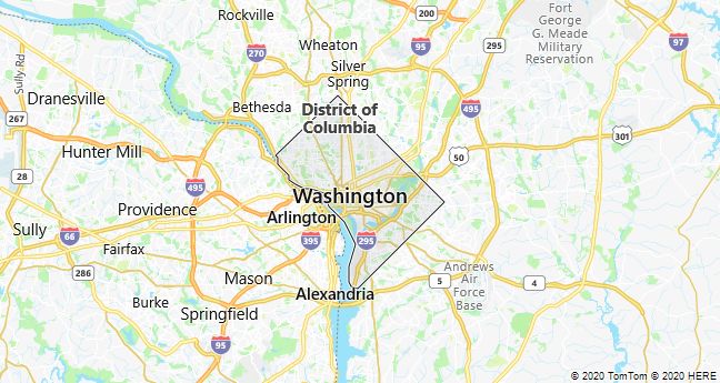
District of Columbia
District of Columbia, DC, the federal district that houses the U.S. capital, Washington. The area has a special status and is not one of the Union’s 50 states.