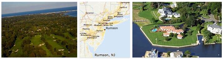
Rumson is a borough located in Monmouth County in the US state of New Jersey.
Summary
Rumson was formed as a borough by an Act of the Legislature of New Jersey the 15 of March of 1907, from portions of the City of Shrewsbury, New Jersey, based on the results of a referendum held on 18 of June of 1907.
Geography
It is located at 40 ° 22 ″ N, 74 ° 0 ″ W (40.369644 – 74.001667). According to the United States Census Bureau, the city has a total area of 18.8 kilometers (7.2 miles). 13.5 km² (5.2 miles) of it is land and 5.2 km² (2.0 miles) of it (27.76%) is water. Public parks include Meadowridge Park, Piping Rock Park, Riverside Park, Rogers Park, Victory Park and West Park.
Demography
As of the GR2 census of 2000, there were 7,137 people, 2,452 households, and 1,988 families residing in the city. The population density was 527.9 / km (1,366.0 / mile). There were 2,610 housing units at an average density of 193.1 / km (499.5 / mi). The racial makeup of the city was 97.77% White, 0.24% African American, 0.06% Native American, 1.06% Asian, 0.36% from other races, and 0.50% from two or more races. Hispanic or Latino of any race was 1.39% of the population. There were 2,452 households out of which 44.2% had children under the age of 18 living with them, 71.3% were married couples living together, 7.8% had a female head of household without the presence of the husband and 18.9% were non-families. 16.8% of all households were made up of individuals and 7. 9% have an elderly person over 65 years of age. The median household size was 2.91 and the median family size was 3.29. In the city the population was spread out with 31.9% under the age of 18, 3.5% from 18 to 24, 26.6% from 25 to 44, 25.2% from 45 to 64, and 12.8% who are 65 years of age. age or older. The median resident age is 39.2 years. The median age is 39 years. For every 100 females there were 93.9 males. For every 100 females age 18 and over, there were 89.6 males. The median income for a household in the city was $ 120,865, and the median income for a family was $ 140,668. Males had a median income of $ 100,000 versus $ 47,260 for females. Per capita income for the city was $ 73,692. About 3.4% of families and 3.2% of the population were below the poverty line, including 2. 4% of which are under 18 years of age and 0.7% of those are over 65 years of age. The ancestries of residents are: Irish (33.4%), German (17.9%), Italian (16.4%), English (13.8%), Polish (6.2%), United States (5.3%).
History
Legend has them that the town’s name is derived from the early settlers who bought the piece of land now known as Rumson from Native Americans for some rum. But from 1663, long before the area was officially named Rumson, Native Americans called it “Navarumsunk.” Over the years it has been “shortened Rumson”. In 1907, Rumson was officially incorporated as a city. Other names that Rumson has become known by include Port Black, Washington, and Oceanic. Rumson was bought by English settlers in pieces. The first purchase is dated January 25, 1665, and included parts of Middletown. The rest of the area was bought on As April 7 as 1665 and 5 as June as 1665. There are many old, historic homes in Rumson, but the oldest was always the 700-acre Tredwell House, named after a family that summered here for nearly 100 years. The oldest part of the house, which was from 1670, was the second oldest building in Monmouth County in June 2006, when it was destroyed by fire. Rumson residents in the 19th century enjoyed many activities, such as swimming in the adjacent Navesink River, the Atlantic Ocean., or take a carriage ride. In winter, they used the river for ice boating. Rumson has always been a very affluent area. In fact, it is still one of the richest cities in New Jersey. The homes are spectacularly large, the Locals enjoy the beautiful beaches just over the Bright Sea Bridge, as well as a fast commuter ferry to downtown Manhattan.